
Advertisement
Mansfield District Council
Map of the Mansfield District Council Area
The area shaded blue on the map represents the extent of Mansfield District Council. The map pin represents the location of the council offices.
Waste Recycling Performance
289 (83.77%) of local authorities perform better than Mansfield District Council.
55 (15.94%) of local authorities perform worse than Mansfield District Council.
Mansfield District Council has a population of 100,600.
Mansfield District Council is within the ceremonial county of Nottinghamshire
click to enlarge
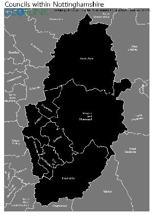
Download Print Quality PDF of Councils in Nottinghamshire
Councils Neighbouring Mansfield District Council
Wards within Mansfield District Council
click to enlarge
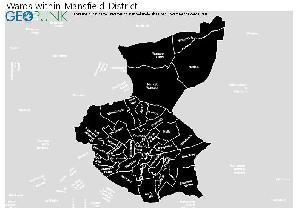
- Kingsway
- Ladybrook
- Lindhurst
- Ling Forest
- Manor
- Market Warsop
- Maun Valley
- Meden
- Netherfield
- Newgate
- Newlands
- Oak Tree
- Oakham
- Park Hall
- Peafields
- Penniment
- Portland
- Racecourse
- Ransom Wood
- Sandhurst
- Sherwood
- Warsop Carrs
- Woodhouse
- Woodlands
- Yeoman Hill
- Abbott
- Berry Hill
- Brick Kiln
- Broomhill
- Bull Farm and Pleasley Hill
- Carr Bank
- Eakring
- Grange Farm
- Holly
- Hornby
- Kings Walk
Download Print Quality PDF of Wards in Mansfield District Council
Mansfield District Council Contact Details
| Website | http://www.mansfield.gov.uk/ |
| Contact Us Page | http://www.mansfield.gov.uk/article/5968/Contact-us |
| Address | Civic Centre |
| Chesterfield Road South | |
| Town | Mansfield |
| County | Notts |
| Postcode | NG19 7BH |
| Telephone Number | 01623 463 463 |
| Fax Number | 01623 463 900 |
| Main Contact Email | mdc@mansfield.gov.uk |
Details for Mansfield District Council
| Local Authority Name | Mansfield District Council |
| SNAC Code | 37UF |
| Postcode | NG19 7BH |
| Latitude | 53.1511157504 |
| Longitude | -1.20490549575 |
| Country | England |
| NHS Health Authority | East Midlands |
| Parliamentary Constituency | Mansfield |
| European Electoral Region | East Midlands |
| Primary Care Trust | Nottinghamshire County Teaching |
| Region | East Midlands |
| Admin County | Nottinghamshire |
| ONS Code | E07000174 |
Waste and Recycling Rates for Mansfield District Council 2017-18
Waste Recycling Performance
289 (83.77%) of local authorities perform better than Mansfield District Council.
55 (15.94%) of local authorities perform worse than Mansfield District Council.

| Authority Type | Collection |
|---|---|
| Waste per household KG | 600.1 |
| Percentage of household waste sent for reuse, recycling or composting | 32.60% |
| Collected household waste per person (kg) | 400.9 |
Employee Headcount for Mansfield District Council
FTE = Full Time Equivalent
| Region | East Midlands |
|---|---|
| Total Headcount | 764 |
| Total FTE | 674 |
| Male Full Time | 356 |
| Female Full Time | 189 |
| Male Part Time | 50 |
| Female Part Time | 169 |
| Permanent | 737 |
| Temporary/Casual | 27 |
| Male | 406 |
| Female | 358 |
| Full-time | 545 |
| Part-Time | 219 |
| Male Full Time perm | 345 |
| Female Full Time perm | 176 |
| Perm Male | 393 |
| Perm Female | 344 |
| Perm Full-time | 521 |
| Perm Part-time | 216 |
| Male total FTE perm | 374 |
| Female total FTE perm | 274 |
| Male Full Time temp | 11 |
| Female Full Time temp | 13 |
| Temp Male | 13 |
| Temp Female | 14 |
| Temp Full-time | 24 |
| Temp Part-time | 3 |
| Male total FTE temp | 13 |
| Female total FTE temp | 13 |